You’re 15 meters down, drifting along a vertical precipice draped in soft corals. Your dive computer says one thing, your guide’s hand signals say another, and the map back at the resort? Well, that’s a whole different story. If you’ve ever tried to reconcile the dive maps of Eastern Bunaken, you know that underwater “borders” are often more fluid than the ocean itself.

The Fluidity of the Map
Mapping the underwater world is an exercise in creative interpretation. Unlike a city street with fixed addresses and signposts, a reef is a continuous living organism. Where one dive site “ends” and another “begins” is often decided by where a boat captain chooses to drop the shot line or where a resort’s historical preference lies. In the North Sulawesi diving mecca of Bunaken Marine Park, the Eastern Wall is a prime example of this cartographic tug-of-war.
A Tale of Two Resorts: Bastianos vs. Two Fish
When we look at the stretch of wall North of the Dive Site Muka Kampung, two heavyweights of the region—Bastianos Dive Resort and Two Fish Divers—provide a fascinating case study in ‘agreeing to disagree.’
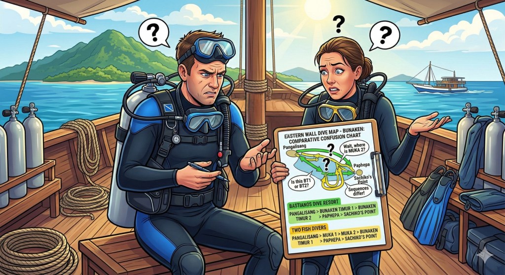
Both resorts start on common ground: once you move past Muka Kampung at the southern tip, everyone agrees you are at Pangalisang. It’s a classic Bunaken wall, teeming with life. But as the current carries you further north, the labels start to shift.
- The First Divergence: Immediately after Pangalisang, Bastianos identifies the stretch as Bunaken Timur 1. Two Fish, however, labels this same area Bunaken Timur 2.
- The “House” Factor: The middle section is where it gets exciting. Two Fish claims a stake in the wall with their own backyard markers, identifying Muka 1 and Muka 2 (their house reef) as the buffer between the Timur sites. Bastianos sidesteps the “Muka” labels entirely, letting Bunaken Timur 1 flow directly into Bunaken Timur 2.
- The Realignment: After this middle-zone shuffle, Two Fish places their Bunaken Timur 1 further north.
Interestingly, as you approach the northeastern bend, the maps sync back up. Both resorts find common ground at Pahepa, and both conclude the journey at the iconic, turtle-heavy Sachiko’s Point.
| Feature / Location | Bastianos Map | Two Fish Map |
| South End | Pangalisang | Pangalisang |
| The Shift | Bunaken Timur 1 | Bunaken Timur 2 |
| Mid-Section | Bunaken Timur 2 | Muka 1 & Muka 2 (House Reef) |
| North-East Transition | Pahepa | Bunaken Timur 1 & Pahepa |
| North End | Sachiko’s Point | Sachiko’s Point |
The Nature of Underwater Borders
Why the discrepancy? It often comes down to perspective and proximity. For a resort like Two Fish, their house reef is a central landmark, so it makes sense to define the surrounding sites in relation to that “home base.” For others, the “Timur” (East) designations are simply a numerical way to chop up a long, continuous reef.
Conclusion: Nothing is Set in Stone (or Coral)
The next time you find yourself debating exactly which site you just dove, remember that dive maps are not legal documents—they are stories told by the people who dive there every day. In the world of scuba, “borders” are just suggestions made of bubbles and salt.
Whether you call it Timur 1, Timur 2, or simply “that spot with the massive gorgonian,” the reef remains the same. The fish don’t know they are crossing from a “House Reef” into a “Timur” site, and perhaps we shouldn’t worry too much about it either. In the end, the only map that genuinely matters is the one you carry back in your memory after the safety stop.

Leave a comment